Friday, August 29, 2008
'No Canister Required' Tour - Day 9 Iva Bell Hotsprings to Reds Meadows Resort
(Click any photo to enlarge) I was up first as usual to make coffee for us and to take a few morning photos. The day had a melancholy feel as we all knew it was our last day. On one hand we crave hot showers, cold Negra Modelo and Mexican food, but on the other none of us want to leave our simple outdoor existence. One of the best things about long hikes is the pure simplicity of the daily routine. Everything we need is held within a small backpack. Re-entering the 'real world' is not something we look forward to. With that said we still packed up and started our 14 mile walk to Reds Meadows. After about an hour we came to the Island Crossing Bridge on Fish Creek. Very pretty area. There were many pools that held nice size trout. (Imagine that with a name like Fish Creek) We eventually exited the Fish Creek drainage and turned Northeast toward Reds. We left the shade of the aspens and entered a granite dominated drainage that we would follow to our destination. There were places where the trail was star drilled (chiseled) right out of the granite. Even though there were no passes today, the trail had a lot of ups and downs and was VERY overgrown. Our legs were scratched and bloody by the time we started to see day hikers on their way to Rainbow Falls, a popular day hike (2 miles) from Reds Meadows. Its funny how your hiking tempo increases over the course of a long walk. As we came upon day hikers we would blow by them like they we standing still. We saw more people in the last two miles than we did on the whole trip. Everyone seemed to smell so good. I think it was because we smelled so bad (except Christi of course). I became immediately aware of my trail stench. We arrived at the resort and went into the store and bought a couple of cold beers. We walked outside to take our finish photo and to wait for the shuttle to arrive. The shuttle took us to the waiting Black Rocket in the Mammoth Mtn Ski area parking lot. What a trip! Not one blister between the three of us in 120 miles. I'll call that a successful outing.
Monday, August 25, 2008
'No Canister Required' Tour - Day 8 Squaw Lake to Iva Bell Hotsprings
(Click on any photo to enlarge) We woke up refreshed and well rested. The photo above is the view we had over coffee. Hiking only 8 miles yesterday almost seemed like a day off. Today was a treat for all of us as we were leaving the JMT to enter Cascade Valley. This deviation from the trail is the way we get around being 'required' to carry a bear canister. If we were to stay on the JMT North we would be fined if caught without a canister. I think this this is totally ridiculous anywhere except Yosemite. The only time we've ever even seen black bears, we've been within 3 miles of a trailhead. We joke that food stealing bears in the backcountry are a joke perpetrated by Rangers. (We also joke that Giardia is another lie started by the same Rangers as we have drank many times from backcountry water sources, without treating, with no ill effects) None of us have been in the Cascade Valley/Fish Creek area before. We packed up and were on trail at 7:30am. After a few miles we reached our turn off and left the JMT for good. We immediately saw the reason it is named Cascade Valley. At every turn of the trail, we were greeted with views of water cascading down granite. The trail was over grown in areas and for the first time on the trip we actually had to route find a bit! The trail obviously doesn't see a lot of traffic like the JMT. With all the water everywhere and all the foliage, the mosquitoes started to seek in on us. So even though I wanted to take a bunch of photos, we kept on rollin to stay a step ahead of the annoying bloodsuckers. We had only 13 miles to do today before (hopefully) camping at Iva Bell Hotsprings.
The hotsprings don't see a lot of people because they are out of dayhiker range. Being 13 miles of hard hiking from Reds Meadows, the hotsprings are difficult to get to even for overnighters. Before we entered the Fish Creek Valley (where the hotsprings are), we had to climb up and over a ridge to get out of Cascade Valley. We all noticed the temperature rising as we lost altitude. The hotsprings sit at 7100ft, which is the lowest we've been the whole trip. The descent off the ridge was hot, sandy and heinous. When we reached the Sharktooth Creek convergence we dropped our packs to find the hotsprings and find out if there were any sites close. Funk and I followed a couple of game trails uphill and finally stumbled upon this below:
We were stoked! We found a site close and went back down the hill to get Christi and our packs. Once we set up camp and looked around the area we found another pool.
Both pools were very clean and warm. The upper pool (above) wasn't quite a warm as the first one we found. Funk went exploring up the hill even more and found a few more pools although they weren't as nice as the two lowest pools. We sat in the hotsprings until our fingers and toes were white prunes then walked west a bit to Sharktooth Creek to clean up and do laundry. By then the sun was starting to go down so we went back to camp and had our last dinner for the trip. Our packs will be superlight tomorrow! After dinner Funk and I started taking photos and just chillin on a huge granite boulder enjoying the sunset and the scenery around it. All in all a great day.
Sunday, August 24, 2008
'No Canister Required' Tour - Day 7 Quail Meadows to Squaw Lake
(Click any photo to enlarge) After the long day yesterday we welcomed a short mileage day as we were all pretty tired. We gave ourselves two extra hours of morning time (We left at 9:15am) and only had 8 miles to get to Squaw Lake. Silver Pass is on the docket today, but with only a half day of hiking , I think we can be at Squaw Lake by 2:00pm. As we started hiking I noticed the thunder clouds gathering. I was anticipating afternoon rain and looking forward to a little inclement weather. I tried to capture the dark clouds over Vermillion Cliffs in the shot below.
The hiking was easy today and even though we were tired, none of us had any specific spots that were troublesome. A good sign on a longer hike. The trail was well graded and very well maintained. The scenery was magnificent as usual. I'm glad we're taking a little more time to enjoy things this year. I really feel like we're on a different trail because everyday I'm saying "I don't remember any of this!" Silver Pass came quickly and without much effort. It is one of the lower passes on the JMT (10,895ft) and since we've been over some of the bigger ones already, this one seems pretty tame. A couple of quick photos with the pass sign and down the other side we went.
Our stop for the day was Squaw Lake. Last year this was our favorite spot of the trip. It came at the end of a long mileage day and we were all tired and grouchy. The lake sits up high on a shelf and as you approach from the North, you don't see the lake until you are up on it. Last year Christi and Dave were convinced that we had already passed it without paying attention. I was pretty sure we still had a little way to go. Those two were pissin' and moanin' until we stepped up over the granite shelf to see this. (Photo from 2007 JMT trip below)
Needless to say , we were all very happy to see the lake in all its splendor. We secured the prime spot on the South Eastern shore, tucked behind a small granite boulder. We spent the rest of the evening relaxing, swimming and taking photos. This year when I was planning the trip I knew we all wanted to go back to Squaw Lake. As we approached from the opposite direction (South) you see the lake well before you get to it. It kinda took the surprise out of it.
As we got closer, I could see that someone had arrived before us to secure the spot we had last year. Once we got to the lake we put our packs down and started searching for a new spot. Just past the lake on the edge of the granite shelf was a spot with a great view and enough room for two Shire's Tarptent Squall 2. It was a good thing we found a spot as the clouds from earlier started to spit at us. We put the tents up just in time as the sky opened up and let us have it for about an hour. It was very cool. I love afternoon thunderstorms
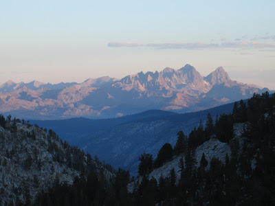
Looking North from our perched campsite Ritter and Banner are visible in the photo below.
After the storm passed, we were treated a magnificent show with a little smoke from the Yosemite fire in the air the sunset had great red and orange colors.
Saturday, August 23, 2008
'No Canister Required' Tour - Day 6 Muir Trail Ranch to Quail Meadows
(Click on any photo to enlarge) Today was painful. Well- really only the last 5 miles were painful. We intended on doing only 13-14 miles today as we have heavily laden packs and Seldon Pass to deal with right out of MTR. Things don't always go as planned. We left MTR at our usual departure time and started the climb up to Seldon Pass. 3100 ft vert in 7 miles. Not too bad. After we reached Sallie Keyes Lake we stopped for breakfast by a snow fed creek.
Breakfast is always the same for Christi and I- powdered milk mixed with cold mountain water, granola and dehydrated blueberries. After chowing and taking a couple of photos we reached Seldon in about an hour. Down past Marie Lake and onto Rosemarie Meadow where the mosquitoes were out in full force. We wasted no time passing through Upper Bear Creek Meadow and continued along Bear Creek. We stopped for a swim break on Bear Creek. Funk found a small waterfall to lay under. It was good to take a break as it rejuvenated us to continue on. We figured we'd go a couple more miles and call it quits for the day. After walking for a bit longer it was becoming obvious that we weren't going to find anything as there was no level ground anywhere. We searched and searched for a site but had no luck. So we just kept walking.
Before we knew it we were descending the 72 switchbacks of Bear Ridge, well past our days proposed finish point. I remember this climb from last year. It sucked. I was counting switchbacks and just got fed up after 50. I was happy we were going down it at 8:00pm instead of going up. Finally at about dark we rolled into Quail Meadows, exhausted, and hastily made camp. Even though it was pitch black out we all took a dip into the river to get he trail grime off and to reduce any inflammation in our legs. I fell asleep as soon as I was under my quilt. We ended up doing 20.5 miles with our heaviest packs of the trip. Tomorrow will definitely be a short day!
'No Canister Required' Tour - Day 5 Evolution Meadow to Muir Trail Ranch
(Click any photo to enlarge) The photo above is what I woke up to this morning. Today we pick up our halfway point food drop at Muir Trail Ranch. We have used the Ranch for the past three years and love the place. I was surprised to hear a couple of Southbound hikers say that they had heard bad things about MTR. I'm here to tell you that they rock. Pat (the lady that runs the place) is a super lady that has been in the Sierra a long time and runs a great business. We always have fun chatting with her while we're devouring Pringles or black licorice or whatever treat we've packed for ourselves. The other bonus of picking our food drop from MTR is Blaney Meadows Hotsprings. From MTR if you head straight toward the San Joaquin River, ford it, and follow the use trails you'll be in for a backcountry treat. Just behind the hotspring is Warm Lake. It has some geothermal activity but it is a bigger body of water so the temperature is not hot but its also not ice cold mountain water. Very Nice!
So we picked up our buckets (you have to ship your food in a 5 gallon pickle bucket so the rodents don't get into it) and stuffed our faces with treats that we had packed specifically for this day. We limit ourselves to two pounds of food per day each. So we pack a bunch of treats that we have to eat before we pack up and leave in the morning. We sorted our food, deposited our garbage from the past four days in the MTR trash cans, and headed down to ford the river. After we got our fill of Warm Lake and the hotsprings, we re-forded the river and found a great little spot on the trail side of the river. Last year fording the river at 6:00am was cold and not really enjoyable. We learned from that and kept our feet dry the next morning by staying on the other side of the river. We fell asleep fat and happy.
'No Canister Required' Tour - Day 4 Upper Big Pete Meadow to Evolution Meadow
(Click on any photo to enlarge) Muir Pass from the South is tough. We have done this pass from both sides multiple times and every time we come from the South it still works me! We started our day as we do most days with my alarm going off at 5:45am. I'm usually awake already so I try to exit the tent quietly so Christi can get a little extra rest if needed. I retrieve our Ursacks from whatever tree we tied them on the night before, and get a liter of water boiling for all three of us to have a cup of Joe. I will usually hand Dave and Christi their coffee while they are still in their bags. Then I'm off to take photos while those two pack up. Its a great system and we become a well oiled machine after a couple days on the trail. We left our site at 7:00am which is about the time we get on trail most days. We were at the Muir hut by 10:00am. Obligatory photos followed then the descent into Evolution Basin. The Evolution basin is heavily traveled and rightly so. It is a very scenic area with beautiful views of Mts Darwin and Mendel and of course the Evolution Lakes. The highest of the lakes (Maps show Evolution Lake as one lake. In reality its more like three lakes that are separated more or less depending on the severity of the previous winter) is the most deep color turquoise that you will ever see in a mountain lake. My photos don't do it justice.
We had planned on camping around Colby or McClure Meadows for the evening so we continued our downward journey. Our lunch stop was at the 'lowest' (and warmest) of the Evolution Lake(s). We all went swimming, ate some snacks then moved on down the trail following the head waters of Evolution Creek. When we arrived at Colby Meadow, we waded across the creek (river) and started to look for a site. As soon as we set our packs down a huge plume of mosquitoes rose from the grass and zeroed in on us. We made the snap decision to find another site, one with a breeze and therefore (hopefully) less mosquitoes. We high tailed it back across the creek (river) and started running away from the dreaded blood suckers. Christi REALLY doesn't like mosquitoes and THEY KNOW IT. She will bathe in DEET to keep them at bay. I swear she'll get ten bites and I'll get one. They sense her fear. Maybe its because I smell really bad in the back country and mosquitoes leave the shit for the flies. (coincidentally- I hate Deer/Horse Flies and they love me) Anyway we found a site on little bluff just above Evolution Meadow and close to the creek. So we weren't too bothered (no more than normal Sierra Mosquitoes) for the rest of the evening. Our bodies are all responding well to the mileage and the altitude. Although we do resupply tomorrow so maybe the reason we all feel good is our packs are the lightest they've been all trip! I think I was asleep before 9:00pm tonight.
'No Canister Required' Tour - Day 3 Upper Basin to Upper Big Pete Meadows
(Click on any photo to enlarge) Mather from the South is one of the easiest of the high passes on the JMT. We were on top of it in less than one hour after breaking camp and being on trail by 7:00am. As we started to descend the other side, we realized how hard the Northern approach of Mather really is! We couldn't believe that we didn't remember any of the climb, except the Golden Staircase, from last year. Last year Mather came on a 20 mile day and we all had our heads down focusing on the trail as opposed to looking around and enjoying the beautiful terrain. We were all glad we were going down it instead of the alternative. Palisade Lake and its corresponding drainage Palisade Creek are some of my personal favorite areas on the JMT and in the High Sierra in general. Last year we stopped at Palisade for breakfast and it was calm and very scenic. I always love entering this area. As we lost altitude and headed for LeConte Canyon and Grouse Meadows the shade of the aspens in Palisade Creek Canyon were a welcomed deterrence from the mid August sun reflecting off the granite. After a few hours we started getting hungry and and decided to try to get to Grouse Meadows for our lunch break. We found a suitable spot and relaxed for about an hour at a georgeous bend in the Middle Fork of the Kings River. Funk and I started getting photo happy as we tend to do on our trips. Funk is a fantastic photographer and I learn so much from him that some of my photos actually look pretty good! As we relaxed a doe and her two kids decided to cross the river just below our lunch spot. It was neat to see that she didn't feel threatened by us and the three of them went about their business. 'The Machine' was done relaxing so that meant it was time to leave. Christi doesn't like to linger at beautiful sites like Funk and I do. When there is mileage to be done she wants to get on with the task. I guess its a good thing as Funk and I would probably still be out there if she wasn't driving us all the time. We made our way past the LeConte Ranger Station and headed up through Little Pete Meadows then to our camp above Big Pete Meadows. We found a great spot next to the river and went through our evening routine and were in our bags sound asleep by hikers' midnight.
Friday, August 22, 2008
'No Canister Required' Tour - Day 2 Taboose Pass to Upper Basin
(Click on any photo to enlarge) Up at 6:00am and on the trail by 7:00am. We all were excited to finally be on the trail again. Of course Christi (Trailname 'The Machine") set tempo up the climb and soon Funk and I were relegated to photo taking backmarkers. We were used to her Mexican Death March as she is usually first to the top of all the high passes, but Funk and I were saving a little since Taboose has a reputation for being rude and unwelcoming. (Stats on the climb- 6000ft ascended in 8 miles) We gained the pass sooner than expected and realized that all of the bad stuff we had read about Taboose Pass was over inflated. We found it easier than the North side of Mather or the South side of Muir. Maybe it was because we were so impressed with the scenery. We made the pass in 3hr 40min, stopped for the obligatory high point photo, and started down the other side.
About an hour later we were on the JMT heading North! The weather was fantastic and we were all felling good so we continued up into Upper Basin to camp just below Mather Pass. We were all pretty surprised how far we had made it on our first 'official' day on the trail. We set up camp at 2:00pm (that NEVER happened in the past two years) about 900 vertical feet below Mather Pass.
I forgot to give a route description in the first post, so for those of you that are interested- Start at Taboose Pass Trailhead up and over to JMT North. Mather, Muir, food drop at Muir Trail Ranch, Seldon, Silver, then a little deviation. After our camp at Squaw Lake (our favorite camp on last years JMT trip) we turned and headed for Cascade Valley and Fish Creek. We had heard of some magnificent areas that see seldom use, and possibly had some back country hotsprings. Then finally exiting at Reds Meadows taking the bus to the Mammoth Mtn ski area where our car sits. Not bad for 8 days! I had scheduled a few shorter days in hope that we would relax a little on some afternoons. (Not an easy thing to do with 'The Machine' at the front)
We settled in and were all asleep by hikers midnight (9:00pm). The night was surprisingly warm for our 11,000+ft altitude.
'No Canister Required' Tour - Day 1 Taboose Pass Trailhead
(Click on any photo to enlarge) Its a pretty ominous feeling when you've just been dropped off in the middle of nowhere, the sun has just set behind the mountains and your friends are driving away down a lonely dirt road. Then add the realization that you have to walk 120 miles to your car! That is just how we felt on Sunday night when our friends Kent and Debra drove us to the infamous Taboose Pass Trailhead. This Eastern Sierra access point is notorious for its difficulty and unrelenting gradient. Of course I picked this as our entry point for the 'No Canister Required' Tour that the three of us embarked on Aug 10. A little background on this years trip- For the last couple of years, our big trip was the JMT North to South. Classic route, bear canisters, no deviations, 16-22 miles a day, just get up and knock out the mileage. That's all fine and dandy but this year I wanted something different. We only had 9 days off so a 200+ mile trip was out. I studied the maps and came up with a route that didn't require us to carry bear canisters, fit into our time schedule, but still allowed us to see our favorite places on the JMT. This years route also had the added benefit of including trails and areas that none of us had ever visited! (Imagine that, in the Sierras??) So with the Wilderness Permits obtained, food drops mailed and several 2-3 day trips to get the gear sorted and processes refined, we finally found ourselves at the Trailhead with just our packs and the Goodale Divide staring at us almost daring us to enter into its inhospitable coven. So at 7:20pm on Sunday Aug. 10 we set out on our journey. We had originally intended on sleeping at the Trailhead. Well........ Taboose Pass Trailhead is just that- a 'trail head'. No parking, no water, no trash cans, no nuthin'. So we set off up the trail in hope of finding a spot to camp since we were all tired from a long travel day. Christi had been up since 1:30am! The trail was dry, sandy and started climbing immediately. After 2 hours of hiking we finally found a primitive spot and collapsed after setting up the tents. To say we slept heavily is an understatement.
Subscribe to:
Posts (Atom)